|
DESCRIZIONE (a cura dell'Editore)
|
12 belle fotografie
meteorologiche di grande formato, piů la copertina, ci accompagnano
mese per mese durante tutto il nuovo anno. Sul retro di ogni pagina
troviamo un ampio commento bilingue (inglese e tedesco) relativo
all’argomento rappresentato dalla fotografia del mese, con molte altre
informazioni meteorologiche e climatiche. Non solo un calendario, quindi, ma un vero e proprio libretto ricco di
informazioni, da conservare e collezionare. Un corposo lavoro curato
da un team europeo di specialisti, con la supervisione dell’
European
Meteorological Society.
|
|
LE
IMMAGINI DELL'EUROPEAN METEOROLOGICAL CALENDAR 2014 |
|
|
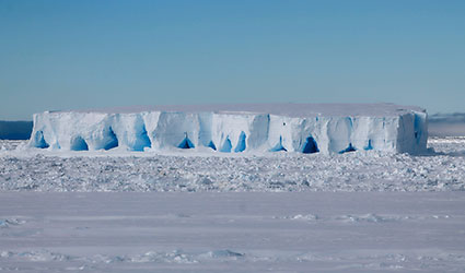
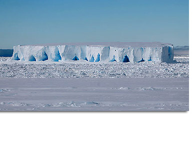
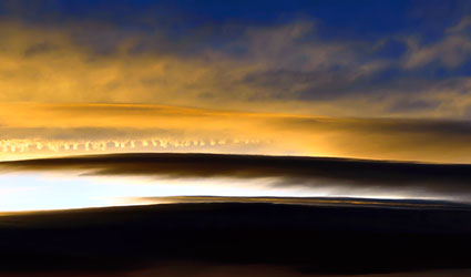
COPERTINA
Christmas-like ambience in Antarctica during mid-summer,
on board the ”Polarstern“, Atka Bay, on route to Neumayer Station III,
21 December 2012
Photographer: Nina Machner
Within minutes the weather
showed its many sides, ranging from a radiant blue sky to a thick wall
of fog. The wind swept across the sea with up to 11 Bft, and generated
waves up to 8 metres in height. The temperature was mostly around the
freezing point. The turbulent waters and melting processes have left
their mark on the drifting iceberg, whose shape has considerably changed
over time. The rough sea, for example, has carved cavities into it. The
overall white appearance of icebergs is caused by light reflecting in
air enclosed in the ice. Icebergs are also often streaked with veins of
clear blue ice, which consist of meltwater that has seeped into glacier
crevasses and has then frozen again. |
|
|
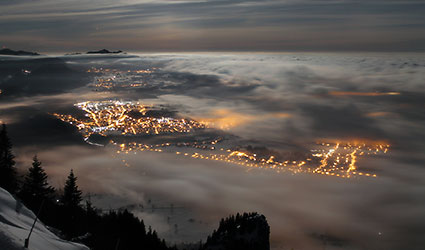
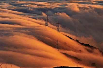
GENNAIO
Fairytale view,
Tegelberghaus mountain hut, Eastern Allgäu, Bavaria (1,707-m altitude):
View towards Füssen, Schwangau and Lake Forggensee, 24 January 2014
Photographer: www.foto-webcam.eu
A blanket of high-lying fog lies over both the
slopes of the mountain beneath the webcam’s position and Lake Forggensee
somewhat to the north. Lying between them, the mostly illuminated valley
between Füssen and Schwangau is almost free of fog. Particularly as a
result of the patches of fog lit from below, this creates an almost
fairytale-like landscape. |
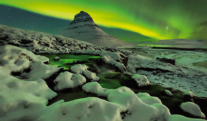
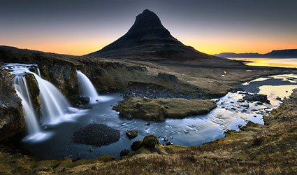
FEBBRAIO
Solar storm, Kirkjufell, Snaefellsnes Peninsula,
Iceland, 7 November 2012
Photographer: Dennis Polkläser
Considerable Northern Lights activity was forecast for this night and,
following previous attempts to observe them that, however, were less
successful as a result of the weather, hopes were high that the weather
forecast would prove to be correct. With increasing darkness, an
initially faint glow in the starlight sky suddenly transformed into a
brightly shimmering auroral band that extended right over the Kirkjufell,
a pyramid-shaped mountain. During the course of the evening the aurora
borealis continually increased in intensity and, after more than one
hour, the band finally broke and illuminated the entire sky in an eerie
green colour that was reflected in the snow. |
MARZO
Sea of
clouds, near Malaga, Spain, 23 December 2012
Photographer: Juan Ortiz Rivas
The evening before Christmas Eve 2012, the meteorological situation over
the South of Spain was marked by the presence of stability. Low clouds
appeared near the coast. From the mountains we could enjoy a great image
of the sea of clouds, which fell from the mountains surrounding the city
of Malaga. |
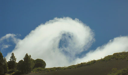
APRILE
Cloud curl, Gran Canaria, 1 May 1 2011
Foto: Fernando Bullón Miró
Although it had been raining heavily the evening and night before, the
first day of May began with an intensely blue sky, just a few clouds
above the ocean and no clouds over the island. The heat from the sun
caused sea breezes to blow inland, whereby several low clouds formed
above the mountains. In the picture we can see one of these first clouds
above the island’s interior, caused by currents of air ascending the
mountains. When I saw the cloud vortex I took the picture as quickly as
possible because I feared that it would only last for a very short time.
And that’s exactly what happened: a few seconds after taking the picture
the cloud had completely lost its amazing shape.
|
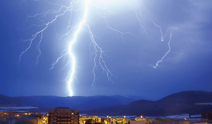
MAGGIO
Lightning, Vicar, Almería, Spain, 19 June 2012
Photographer: José Miguel García García
Numerous thunderstorms cells developed north of Vicar, whereby the
thunderstorm activity lasted for seven hours! Although most of the cells
were dry or with very little precipitation, they were accompanied by
considerable lightning that was sometimes very intense and close to
where I was standing. The lightning caused several fires in the
mountains of Gador. The fire caused by this bolt of lightning lasted for
one hour until one of the last cells crossed over the area. Fortunately
this cell contained enough water to extinguish the fire. |
GIUGNO
Painted clouds, near Barcelona, Spain, 21 December 2011
Photographer: Jordi Martín García
Shortly after taking off from Barcelona Airport, Spain, we had the
feeling that anyone who enjoys meteorology was about to experience an
interesting day in terms of the weather. When we reached an altitude of
18,000 ft (around 6,000 m) our wishes came true: the first light of day
illuminating these altocumuli lenticulari, plus the extra bonus of being
able to see the contrail from another aeroplane that had just crossed
our route to Madrid a few moments before, made us feel particularly
privileged that we were able to enjoy such spectacular views during this
early morning flight. |
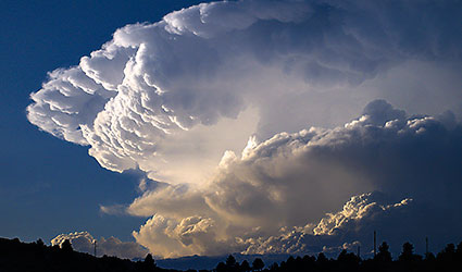
LUGLIO
Thunderstorm with anvil, near Barcelona, Spain,
August 5, 2012
Photographer: Felipe G. Fuertes Rodríguez
As usual, the summer of 2012
was very hot in Spain. In particular, the hot air at ground level
provided one of the ingredients for a very explosive cocktail. During
the first weekend of August a cold front crossed the Iberian Peninsula
giving us our second ingredient for our meteorological cocktail:
high-level cold air. The formation of a low depression between Catalonia
and the Balearic Islands then provided the third and decisive component:
humid air from the Mediterranean Sea („Sistema Ibérico“). This
combination resulted in the formation of clouds with a high vertical
extent in the mountainous regions. This photograph was
taken in front of a powerful cumulonimbus capillatus with extreme
meteorological characteristics such as intense rain, hail and strong
winds. |
AGOSTO
Summer sunset, Kirkjufellfoss, Snaefellsnes Peninsula, Iceland,
4 May 2012
Photographer: Dennis Polkläser
After a short and icy night in the car with barely a moment’s sleep, and
the thermometer showing a temperature just over the freezing point, I
started to use the early light to take photographs at around 2:40 am. At
this altitude there is no longer any complete darkness by the beginning
of May. Following a prolonged and intensive sunset during the previous
evening, a narrow strip of light remained on the horizon that increased
in intensity again shortly after midnight. This photograph was taken
around 3:00 am, roughly two hours before sunrise. |
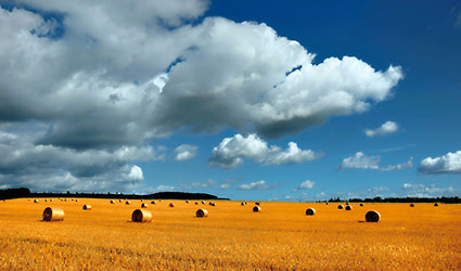
SETTEMBRE
Late-summer fair weather clouds, Erzgebirge mountains (Saxony),
26 August 2012
Photographer: Jan Oesen
The contrast between the blue sky, pale blue clouds and the harvested
yellow cornfield creates an ambiance typical of later-summer weather
conditions. The sun is to the rear of the photographer so that the straw
bales on the field cast short shadows to the left, i.e. towards the west
from where the clouds are gathering. On this day the temperature
increased further to around 23°C before a cold front eventually brought
rain and cooler temperatures during the evening.
|
OTTOBRE
End of the earth, Cape Finisterre, Spain, 7 November 2012
Photographer: José Antonio Quirantes Calvo
An extensive layer of altocumulus stratiformis approached Cape
Finisterre from the southwest. Six hours later it rained over the area.
The cape is a rocky peninsula on the Atlantic Coast of Spain in the
province of Coruńa. The name Cape Finisterre is derived from the Latin
“Finis Terrae”, which means “end of the earth”. During the Roman Empire,
the cape was believed to be the westernmost point of the Iberian
Peninsula and thus the known world. This is not actually correct because
“Cabo da Roca” in Portugal is about 16.5 km further to the west.
Nevertheless the place has a magical and mysterious quality about it and
is steeped in legend. At the foot of the cape, the Atlantic Ocean is
always impressive and defiant. |
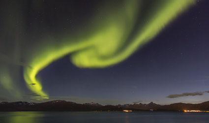
NOVEMBRE
Aurora borealis, Tromsř, Northern Norway, 4–5 September 2012,
midnight
Photographer: Hanneke Luijting
This photo was taken around midnight, September 4-5, 2012. The days are
getting shorter by then, but the twilight still lasts all night –
resulting in a beautiful blue colour in the sky. It‘s a pleasure to
watch the aurora on a mild night like this: the temperature was around 9
degrees Celsius! Later in the season, it‘s a challenge to stay warm when
photographing the aurora on cold winter nights. These auroras were the
result of a
massive solar storm which caused active auroras for several days in a
row. |
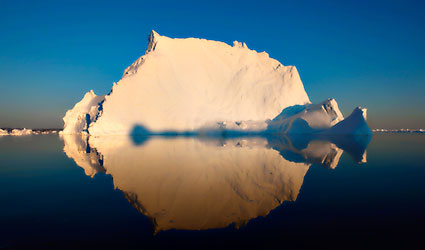
DICEMBRE
Iceberg in Disko Bay near Ilulissat (Greenland), 9 July 2009
Photographer: Jürgen Löffelsender
Even in summer, a mirror-like ocean and a clear blue sky are very rare
in southern Greenland. It looks as if you can also see the iceberg
beneath the water surface, but that is actually a reflection of the
upper part above the water, whereby seven times as much ice lies beneath
the surface. The iceberg is bathed in the yellow glow of the low-lying
sun. With its tapered surface, it has the typical shape of an Arctic
iceberg. In the Antarctic, on the other hand, tabular icebergs
predominantly occur that have broken off from ice shelves (see title
image). |
|